Accessing and Applying Geostationary Lightning Mapper Observations
The AMS Satellite Meteorology, Oceanography and Climatology (SatMOC) Committee is offering two virtual training sessions on investigating observed flashes with the GLM from various use cases.
Participants will be given the opportunity to complete a "homework" assignment before each session to get better acquainted with the session topic. In addition, participants will be able to communicate with the instructors before and after the live training sessions. The homework assignments and communications with the instructors will be made available on the AMS Community website exclusively for course participants.
January 5 and 6, 2022 (Virtual)
| Registration close date: | CLOSED - December 31, 2021 at 11:59 PM EST |
| Participant cap: | 100 |
Registration rates:
There is no fee associated with registering for any of the training sessions.
Registration policy:
This course is being made available to all active AMS members. Registrations are not transferable or exchangeable. The cost of an AMS student membership is $20.
This course is designed to be attended consecutively on both days.
Participants must complete both sessions to receive an AMS certificate of completion.
Course Syllabus:
Day 1
Wednesday, January 5, 2022 at 1:00–2:00 P.M. EST
Session description:
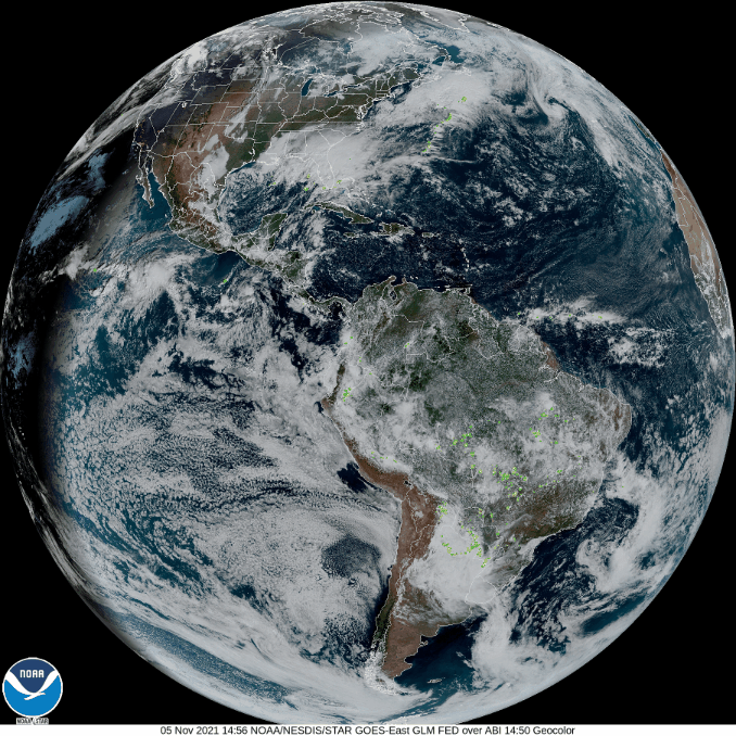
This session introduces the Geostationary Lightning Mapper observations and imagery. GLM flash skeletons illustrate the instrument observation capabilities and characteristics of individual lightning flashes. The session then introduces gridded products derived from the raw GLM Level 2 data and used by the National Weather Service, among other users. Participants are shown how to access archived and real-time imagery before conducting a hands-on exercise illustrating their new-found skills. The session concludes with a participant outbrief documenting the interesting cases/imagery they discover.
Schedule:
| 1:00–1:30 | Introduction to GLM Observations and Imagery (30 min) |
| 1:30–1:45 | Hands-on Exercise: Use GLM website to document cases of interest (15 min) |
| 1:45–2:00 | Hands-on Exercise Outbrief (15 min) |
Day 2
Thursday, January 6, 2022 at 1:00–3:00 P.M. EST
Session description:
This session first explores the value of GLM for diagnosing convection during severe storm warning operations and aviation applications. The session stresses the importance of the GLMs broad coverage and rapid updates, and its ability to observe the complete spatial footprint of total lightning flashes. Hurricane Ida then provides an opportunity to explore various GLM applications as the available observations and associated hazards vary from formation through landfall and extratropical transition. A hands-on exercise on applying GLM imagery during different portions of Hurricane Ida’s lifecycle will be followed by a group outbrief and final thoughts on GLM observations.
Schedule:
| 1:00–1:30 | Overview of GLM use during Convective Warning Operations and for Aviation Applications (30 min) |
| 1:30–1:45 | Introduction to Imagery from Hurricane Ida Case Study (15 min) |
| 1:45–2:30 | Hands-on Exercise: Interpreting and Applying GLM Imagery throughout the Lifecycle of Hurricane Ida (45 min) |
| 2:30–3:00 | Hands-on Exercise Outbrief, Develop Group Presentation (30 min) |
Instructors:

Joseph Patton
UMD/ESSIC/CISESS, Geostationary Lightning Mapper Liaison to the National Weather Service
Joseph Patton is a research scientist with the Cooperative Institute for Satellite Earth System Studies (CISESS) at the University of Maryland-College Park focusing on lightning research and training. His current position involves studying operational forecasting techniques using the Geostationary Lightning Mapper and creating training materials based on lightning information from the GLM for forecasters throughout the Western Hemisphere. Joseph previously served as an operational meteorologist with the National Weather Service in Goodland, Kansas before joining CISESS.
Find him on Twitter: @JosephPattonWx
Scott Rudlosky
NOAA/NESDIS/STAR, Geostationary Lightning Mapper Scientist
Dr. Scott Rudlosky is a Physical Scientist with the National Oceanic and Atmospheric Administration (NOAA) co-located with the Cooperative Institute for Satellite Earth System Studies (CISESS) in College Park, Maryland. His research has focused on the GLM since NOAA began supporting his doctoral work in 2007, and he now serves as the NESDIS Subject Matter Expert on lightning and GLM science lead. Two recent manuscripts and a GLM value assessment study illustrate his work on validating and applying GLM observations. He values mentoring both graduate and undergraduate students, and taught a course on mesoscale meteorology for 5 years at the University of Maryland.
Find him on Twitter: @goesglm
Working Group:
A Working Group on Virtual Training was formed by the AMS Satellite Meteorology, Oceanography and Climatology (SatMOC) Committee with the purpose of teaching and sharing new satellite observations and developments that are not in textbooks as well as enriching and strengthening student skills to use satellite data to examine and/or study extreme events. Its members are acknowledged below:
- Jordan Gerth (NOAA/NWS)
- Eric Goldenstern (Colorado State University)
- Amy Huff (IMSG at NOAA/NESDIS/STAR)
- Scott Lindstrom (University of Wisconsin SSEC/CIMSS)
- Gary McWilliams (Science and Technology Corporation, NOAA)
- Sherrie Morris (NOAA)
- Bill Sjoberg (NOAA JPSS)
- Sara Tucker (Ball)
- Jun Wang (University of Iowa)
- Cara Wilson (NOAA/NMFS/SWFSC)