Atmospheric Profiles (St³ves) and Text Data for Selected
Cities
Rawinsonde is the term for a radisonde instrument that is
tracked to determine wind information. The radiosonde package directly
measures the atmospheric pressure, temperature and humidity at a series
of levels while ascending through the atmosphere attached to a hydrogen
or helium balloon. The
data are radioed back to the launch station during the flight for
immediate decoding. For more information, see
http://en.wikipedia.org/wiki/Radiosonde.
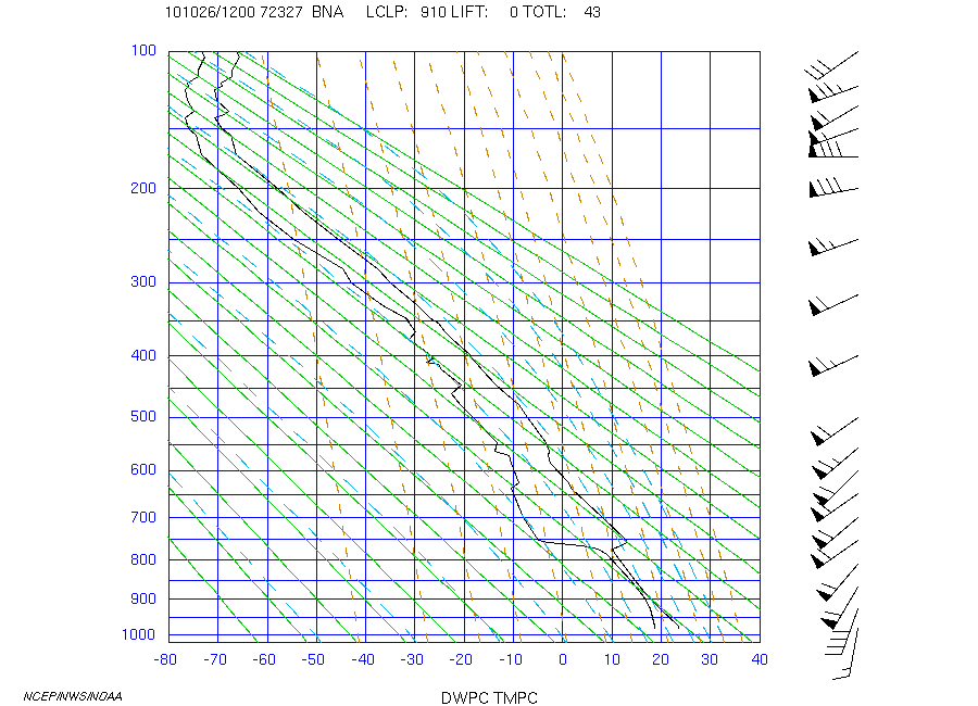
Left: Rawinsonde upper air soundings
("profiles") for individual
stations can be plotted on one particular type of upper air diagram
called a
St³ve diagram. The St³ve heading is the year, month,
date /
hour (YYMMDD/HHHH UTC), World Meteorological Organization station
identifier
number, and 3-letter station code. The sounding for 1200Z (UTC) 26 OCT
2010 (101026/1200) for Nashville, TN (BNA, WMO
#72327) is shown
above.
Additional information includes: the
lifting condensation
pressure level in millibars (LCLP), lifted index level in Celsius
degrees
(LIFT), and the "total totals" value (TOTL). These values provide
information on atmospheric stability.
A St³ve diagram with sounding data contains:
- Temperature sounding data - black jagged
line to right. The temperature scale is given in degrees Celsius along
the bottom from -80 C to +40 C.
- Dewpoint sounding data - black jagged
line to left. the dewpoint data are a measure of the water vapor
content of the air, termed humidity, using the same temperature scale
for the dewpoint.
- Temperature lines - vertical blue lines,
in degrees Celsius.
- Pressure lines - horizontal blue lines,
in millibars.
- Dry adiabats (potential temperature
lines) - solid green lines
sloping towards the upper left. They are lines depicting the
temperature change
of unsaturated air parcels when ascending or
descending.
- Moist adiabats - dashed cyan lines
are sloping curves toward the upper
left. They represent the temperature change of saturated
air parcels
when ascending and releasing latent heat.
- Mixing ratio lines - dashed yellow lines
which represent the
saturation moisture content of the atmosphere.
- Wind barbs - to the right of the
sounding grid, representing winds in
station model format at altitudes indicated by the point of the wind
barb. The
top of the diagram represents north for wind direction. The winds at
mandatory
pressure reporting levels are plotted at their pressure levels, whereas
winds
at various height levels are plotted at their Standard Atmosphere
pressure
level.
Right: The abbreviated list of text data
reported by the
radiosonde ascent at Nashville on 12Z 26 OCT 2010 plotted to the left.
Heading of report:
- Sounding data Station (3-letter
identifier) and World Meteorological
Organization identity code.
- UTC (Z) time and Date
- Station location information: LAT
(latitude in degrees, positive for
Northern Hemisphere), LON (longitude, negative for
Western Hemisphere),
ELV (elevation in meters above mean sea level)
For different levels in the atmosphere the upper air
observation includes:
- PRES - pressure in millibars. **
- HGHT - altitude of that pressure level
in meters.
- TMPC - temperature in degrees Celsius.
- DWPC - dewpoint in degrees Celsius.
- RELH - relative humidity in percent.
- DRCT - wind direction rounded to nearest
5 degrees, clockwise from
true north.
- SKNT - wind speed in knots.
- MIXR - mixing ratio (atmospheric
humidity measure) in grams of water
vapor per kilogram of "dry air".
** If the surface station pressure is less
than 1000 mb, the altitude
of the missing 1000-mb level will be listed (less than station
elevation) and
other values shown as "0".