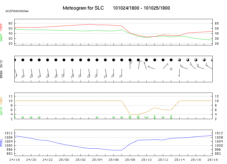
Meteograms for Selected Cities
A city is selected by clicking the mouse pointer on its
identity code from
the map or its name in the selection table.
A meteogram (also termed "meteorogram" or "metgram") is
a 25-hour graphical time series of weather conditions at a station that
contains:
- The Meteogram label shows the three letter identifier of
the station
followed by the year, month, day / UTC time (YYMMDD/HHHH) for the
beginning and
ending of the data interval.
e.g. Meteorgram for SLC 101024/1800 -
101025/1800 is Salt Lake City, UT from 2010 October 24 at
1800 UTC to 2010 October 25 at 1800 UTC.
- TMPF and DWPF are
the temperature in degrees Fahrenheit on
the upper curve (red) and dewpoint (�F) on the lower curve (green),
respectively. The plot scale adjusts to the maximum and minimum
temperatures in
the data set.
- BRBK is the station model wind report
along the lower row of this
section. SKYC is total cloud cover.
- VSBY is the horizontal visibility in
statute miles (brown).
WSYM, if present, is the symbol for weather
conditions that limit
visibility if reported visibility is 10 mi. or less.
- PMSL is the atmospheric pressure
corrected to mean sea level in
millibars plotted on the lower graph.
- Date/Time in Z (UTC) is reported below
the pressure graph. The most
recent time is at the right side of the graph scale.
In the above example, a cold front passed the Salt Lake City
station between 07Z and 08Z on 25 OCT 2010. The changing pattern of falling,
then rapidly rising pressures, falling temperatures and dewpoints, and
wind direction shift from southerly to northerly that occurred between
those times is typical of such passage. Precipitation also occurred
over that period with first rain (light then heavy) and next snow.